For every pilgrimage trail there is also a trekking route. For every monastery hilltop there is a stargazing meadow. Uttarakhand rewards the explorer who goes a few hours past the last tourist town.
A true seeker of experiences in Uttarakhand is one who want more than a hill-station checklist.
In one state, you can trek through bugyals and glacier valleys;
Watch evening aarti where the Ganga leaves the mountains, stay in forest ridges above Kumaon, follow wildlife in Corbett and Rajaji;
And enter a yoga ecosystem in Rishikesh that carries its real lineage.
Two Different Landscapes, Decides Your Experiences in Uttarakhand
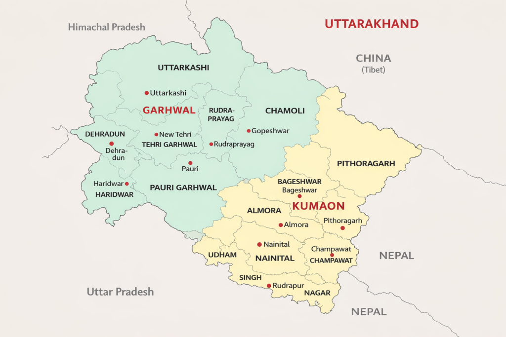
The state has a stark altitude range: 200m – Haridwar to 7,816m – Nanda Devi, second highest peak entirely within India. Uttarakhand divides into two administrative and cultural regions.
Garhwal
The Western Uttarakhand is defined by the Ganga and Yamuna river systems, the Char Dham pilgrimage circuit, and the high Himalayan valleys that extend north to the Tibet border.
Rishikesh and Haridwar sit at the foothills; Kedarnath (3,583m), Badrinath (3,133m), Gangotri, and Yamunotri are the high sacred sites.
The Alaknanda and Bhagirathi rivers carve through deep gorges before joining at Devprayag to form the Ganga proper.
Kumaon
The Eastern Uttarakhand, is gentler, greener, and less pilgrimage-saturated, oak and rhododendron forests, the lakes of Nainital district.
Jim Corbett NP on the terai edge, and the high ridgelines of Pithoragarh and Bageshwar looking toward the Panchachuli and Nanda Devi massifs.
The culture is Kumaoni, distinct from Garhwali in language, festival tradition, and craft.
The state’s southern edge (Shivalik range) holds Rajaji NP and the elephant corridor to Jim Corbett.
The middle Himalayas (1,500–3,500m) carry most settlements.
The Greater Himalaya above 3,500m, where the Char Dham sites, high-altitude bugyals (meadows), and glacier approaches are; is the zone that defines Uttarakhand’s international reputation.
Uttarakhand at a Glance
| Districts | 13 |
| Area | 53,483 sq km |
| Capital | Dehradun |
| Two divisions | Garhwal (west) / Kumaon (east) |
| UNESCO World Heritage | Nanda Devi and Valley of Flowers National Parks |
| Sacred circuits | Char Dham (Yamunotri, Gangotri, Kedarnath, Badrinath); Panch Kedar; Panch Prayag |
| Traditional designation | Dev Bhoomi – Abode of the Gods |
Places in Uttarakhand – That Rewards the Experience Seekers
Chopta
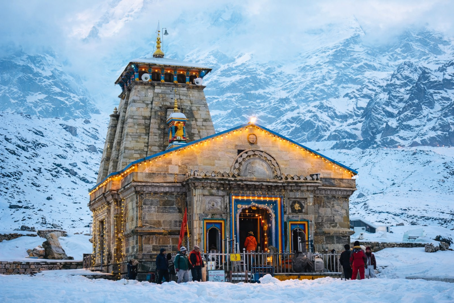
In Rudraprayag district, Garhwal; 2,680m, is a small meadow settlement in the Kedarnath Wildlife Sanctuary, accessed through dense mixed forest – the most underrated high-altitude base in the state relative to what it delivers.
Tungnath (3,680m; 3.5km from Chopta) is the highest Shiva temple in the world and one of the Panch Kedar.
Chandrashila summit (4,130m; 5km) gives a 360° Himalayan panorama including Nanda Devi, Trishul, Kedarnath, and Chaukhamba.
Deoria Tal (2,438m; 3km from Sari village below) is the mirror lake with Chaukhamba reflected.
Experiences in Chopta:
- Trekking(TFS1–TFS3),
- Camping, astro-photography (excellent dark skies within the sanctuary),
- Spiritual (Panch Kedar circuit),
- Nature & Mountain Living,
- Wildlife (Kedarnath WS – Snow Leopard, Musk Deer, Western Tragopan).
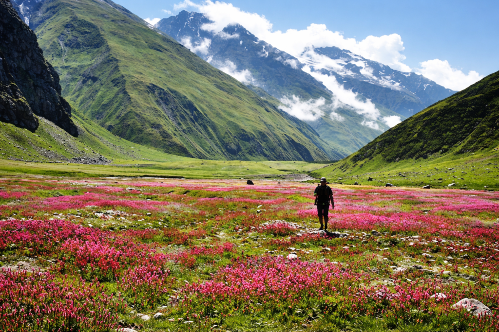
Valley of Flowers Zone – Govindghat / Ghangaria
In Chamoli district, Garhwal; 1,828–3,658m, is where a UNESCO World Heritage and dual pilgrimage sites coexist within the same approach trail.
The Valley of Flowers (87.5 sq km; 3,352–3,658m) has 500+ wildflower species in sequential bloom (Jun–Oct) is a strictly day-use zone with no camping or permanent infrastructure inside.
Its natural character is unusually intact for a UNESCO site of this visibility.
Hemkund Sahib (4,329m) one of the highest Gurdwaras in the world. 19km trek from Govindghat draws Sikh pilgrims from across India alongside the botanical trekkers.
Lakshman Lokpal Temple is revered as the spot where Lakshman meditated; is located next to the Hemkund Sahib Gurudwara, making the area a dual spiritual site for both Hindus and Sikhs.
Experiences in Valley of Flowers
- Trekking (TFS2–TFS3),
- Wildlife (Snow Leopard in upper zones, Himalayan Monal),
- Landscape and astro-photography,
- Spiritual Trek (Hemkund Sahib),
- Camping (Ghangaria).

Rishikesh
In Dehradun district, Garhwal; 356m, has its unmatched concentration of wellness, adventure, spiritual, and volunteer-tourism experiences in a single compact zone despite its well-known status.
The international yoga and retreat ecosystem here is the densest in India:
Over 200 ashrams and yoga schools, the annual International Yoga Festival (Mar), and a lineage of teachers that traces directly to Swami Sivananda’s Divine Life Society (circa 1936).
The Ganga above Rishikesh runs Grade III–IV white-water; bungee jumping at 83m and cliff jumping at multiple sites operate year-round.
The town is also the gateway for the Char Dham pilgrimage, the base for northern Garhwal trekking,
Home to an active volunteer tourism infrastructure serving local community projects.
Experiences in Rishikesh
- Yoga and wellness retreats,
- White-water rafting,
- Spiritual pilgrimage,
- Volunteer tourism,
- Cultural immersion,
- Camping.
Binsar
In Almora district, Kumaon; 2,412m, sits inside the Binsar Wildlife Sanctuary above the old Kumaon hill town of Almora.
A forested ridge with a panoramic viewing point called the Zero Point that faces an unobstructed 300km arc of Himalayan peaks from Kedarnath to Nanda Devi to Panchachuli on a clear day.
The sanctuary holds over 200 bird species, significant Himalayan Black Bear and Leopard populations, and a network of walking paths through old-growth oak and rhododendron.
A handful of heritage bungalows and forest rest houses in the forest make Binsar one of the most distinctive nature/mountain stay destinations in Uttarakhand.
Experiences in Binsar
- Birding, Wildlife photography,
- Nature/mountain stays,
- Landscape photography,
- Cultural living (Almora’s Kumaoni craft and market town is 30km below),
- Cultural Immersion – Aipan art (Kumaon).
Munsiyari
In Pithoragarh district, Kumaon; 2,298m, sits at the base of the Johar Valley.
Facing the five Panchachuli peaks (6,334–6,904m) across a high ridge; one of the most dramatic Himalayan panoramas accessible by road in Uttarakhand.
The Shauka and Bhotiya communities here were historically Tibet traders;
Their culture is documented at the Tribal Heritage Museum, the most important community-level ethnographic collection in the state.
Munsiyari is the approach base for the Milam Glacier trek (TFS3–4) one of the great glacier walks of the Indian Himalaya.
Khaliya Top meadow (TFS2; 3,500m) rhododendron bloom in spring.
Experiences in Munsiyari:
- Trekking (TFS2–TFS4),
- Cultural living,
- Nature & mountain living,
- Craft and artisan immersion,
- Wildlife (Himalayan Monal, Snow Leopard in higher zones),
- Astro-photography.
[These five places are selected for concentration of GDT experiences, not for name recognition. As we expand our field, so shall Field Notes in coming days]
Adventure Side of Uttarakhand: Terrain That Earns Your Respect
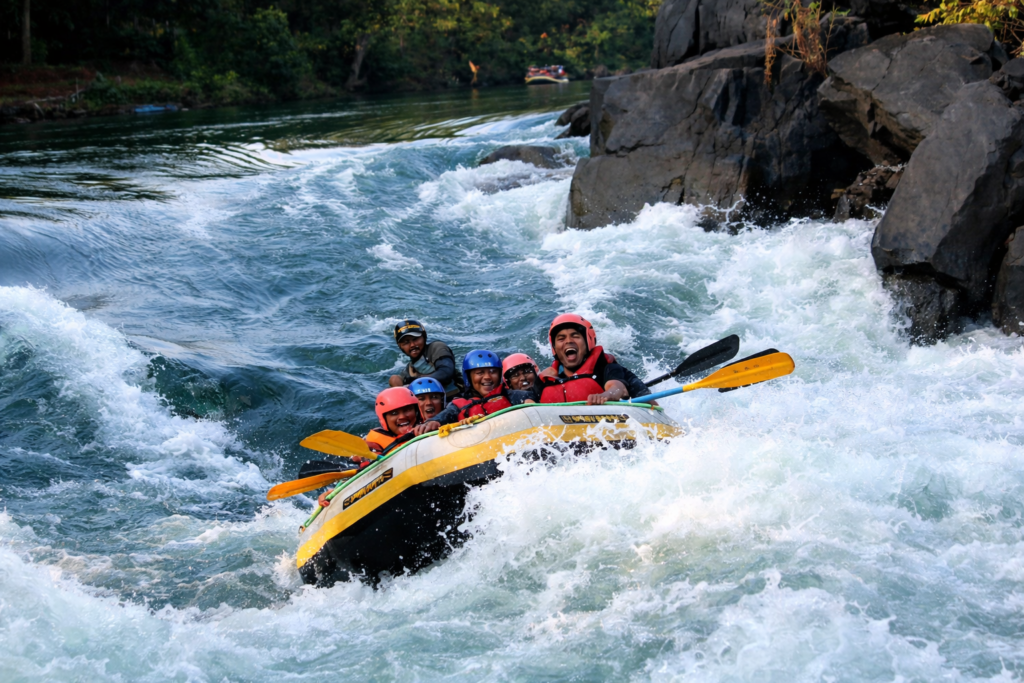
White-water Rafting
The Ganga above Rishikesh from Shivpuri (16km) and Marine Drive (24km), runs Class III–IV rapids that draw the largest volume of commercial rafting in India.
The season runs roughly Sep–June; the Ganga swells too unpredictably for commercial operations during monsoon.
Multi-day rafting camps on the river beach at Shivpuri combine rapids with overnight camping in a setting that manages to be both wild and accessible.
Trekking in Uttarakhand
Uttarakhand is India’s primary Himalayan trekking state. [this is a reference list, for an exhaustive list read GDT’s Complete Trekking Guide in Adventure journals.
Garhwal:
- Kedarkantha (TFS2; 3,800m) winter snow trek from Sankri,
- Har Ki Dun (TFS2; 3,566m) Govind WLS,
- Kuari Pass / Curzon Trail (TFS2–3; 3,640m) panoramic ridge walk,
- Roopkund (TFS3; 4,777m) glacial lake; skeleton site.
Kumaon:
- Khaliya Top (TFS2; 3,500m) Munsiyari known for spring rhododendron,
- Milam Glacier (TFS3–4; 4,250m) inner line permit required,
- Pindari Glacier (TFS2; 3,820m) Bageshwar accessible classic.
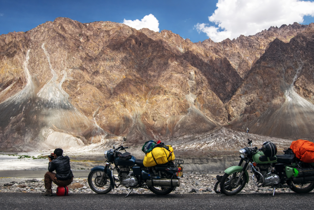
Motorcycle & Overland Expedition
The Char Dham circuit by road (Haridwar → Yamunotri → Gangotri → Kedarnath base (Sonprayag) → Badrinath → Rishikesh) is the most significant religious-overland route in India, covering approximately 1,200km through five river valleys.
The Kumaon circuit (Almora → Binsar → Bageshwar → Munsiyari → Pithoragarh → Champawat → Almora) is a 5–7 day self-drive loop through the most culturally intact zone of the state.
The Uttarkashi district’s Nelong Valley approach (Indian citizens only; permit from DM Uttarkashi) opens a restricted border valley with Ladakh-like landscape that closed in 1962 and was only reopened in 2015.
Skiing in Uttarakhand
Auli (Chamoli district; 2,500–3,049m) is Uttarakhand’s primary ski destination (Dec-Mar). With a gondola from Joshimath (~4km) reaching the main ski slope facing Nanda Devi.
Infrastructure is basic by international standards; the setting and the Nanda Devi backdrop are exceptional.
Munsiyari and Chopta also accumulate sufficient snow for skiing in strong winters but have no formal infrastructure.
Paragliding in Uttarakhand
Mukteshwar (Nainital district; 2,286m) and Naukuchiatal operate paragliding launches in the Kumaon hills with views over the lake district.
Rishikesh has small paragliding operations over the Shivalik range.
None rival Bir-Billing in scale but the Kumaon sites offer shorter-commitment experiences.
Camping and Astro-Photography
The Kedarnath Wildlife Sanctuary (Chopta, Deoria Tal),Govind Pashu Vihar NP (Har Ki Dun zone),
High-altitude meadows above Munsiyari are the premier dark-sky camping zones.
Above 3,000m, away from valley towns, the skies are clear enough for Milky Way photography from Jun–Oct.
India’s Oldest Wildlife Sanctuary is Here – Uttarakhand’s Wilderness
Jim Corbett National Park
Established in 1936 as Hailey National Park, the oldest national park in India; spans 520 sq km of core zone (1,288 sq km total with buffer) in the Terai-Bhabar zone at the state’s southern Kumaon edge.
The Bengal Tiger population here is among India’s highest-density within any named reserve; the park also holds Indian Elephant, Gharial (Ramganga River), Leopard, and one of North India’s richest resident and migratory bird lists.
The Dhikala Forest Rest House, inside the core zone, accessible only to overnight guests, is the most immersive wildlife stay available at Corbett. Season Nov–Jun for vehicle safaris; core zone closes Jul–Oct.
Rajaji National Park
In Haridwar/Dehradun; spans 820 sq km, is the western anchor of the Elephant corridor that runs from Corbett and holds Uttarakhand’s largest elephant concentration.
Tigers, Leopards, Leopard Cats, and the Chilla beat’s bird diversity make it a underrated alternative to Corbett for visitors based in Rishikesh or Haridwar (30–40km from the park gates).
Kedarnath Wildlife Sanctuary
Spans 967 sq km; surrounds Kedarnath temple, is the high-altitude complement. Snow Leopard, Himalayan Black Bear, Himalayan Musk Deer, and Western Tragopan (the most sought-after pheasant of the western Himalaya) in the zone between 1,600–7,068m.
The sanctuary’s winter months, when Snow Leopards descend to lower elevations, offer the best sighting chances for those willing to be in Chopta and the surrounding forest in Dec–Feb.
Nanda Devi Biosphere Reserve & Valley of Flowers
Recognised UNESCO World Heritage; 87.5 sq km Valley of Flowers + 630 sq km Nanda Devi NP core, in 1988 and 2005, respectively.
The botanical diversity of the Valley peaks in Jul–Aug with over 500 wildflower species in sequential bloom – Himalayan poppies, cobra lilies, orchids, Brahmakamal (the state flower).
The upper zone of Nanda Devi NP closed to trekkers since 1983 to allow ecosystem recovery is one of the most protected wilderness zones in India.
Binsar Wildlife Sanctuary
Spans 47 sq km; Almora; 2,412m, punches above its size for birdwatching.
Over 200 species recorded, including multiple woodpeckers, laughingthrushes, flycatchers, and winter visitors from Central Asia.
The sanctuary also holds Himalayan Black Bear and Leopard, and the forest walk from the Zero Point viewpoint is one of the finest short forest walks in Kumaon.
| Protected area | Signature wildlife | Best season |
|---|---|---|
| Jim Corbett NP | Bengal Tiger, Indian Elephant, Gharial | Nov–Jun (safaris); Jul–Oct core zone closed |
| Rajaji NP | Indian Elephant, Tiger, Leopard | Nov–Jun |
| Kedarnath WS | Snow Leopard, Western Tragopan, Musk Deer | Dec–Feb (Snow Leopard); Apr–Jun (birds) |
| Valley of Flowers (UNESCO) | 500+ wildflower species, Snow Leopard in upper zones | Jul–Aug (peak bloom) |
| Binsar WS | 200+ birds, Himalayan Black Bear, Leopard | Oct–Apr (birding); year-round |
Wellness in Uttarakhand has Institutional Roots, Beyond Tourism Banner
The Rishikesh Yoga Ecosystem
Rishikesh carries the title of “Yoga Capital of the World” with genuine institutional weight behind it.
Swami Sivananda established the Divine Life Society here in 1936;
Maharishi Mahesh Yogi’s ashram on the north bank (where the Beatles famously stayed in 1968) helped globalise the city’s reputation.
Over 200 registered yoga schools and ashrams operate here, ranging from traditional Patanjali-lineage centres to internationally accredited teacher training programmes.
The International Yoga Festival (annually in March; Parmarth Niketan; 8 days; international instructors and practitioners from 100+ countries) is the largest yoga gathering of its kind in India.
Serious practitioners distinguish between the ashrams on the north bank above Laxman Jhula – quieter, more traditional, and, the commercialised yoga-hotel zone on the south bank.
Ganga Aarti – Haridwar and Rishikesh
The Ganga Aarti at Haridwar’s Har Ki Pauri ghat, conducted at dusk every evening without exception is one of the most viscerally affecting public rituals in India.
The scale – thousands of oil lamps floated on the river simultaneously by priests and pilgrims;
The sound (conch shells, bells, Sanskrit chants), and,
The location – the ghat where the Ganga officially leaves the mountains and enters the plains.
Combine into an experience that crosses the line between witness and participation.
Rishikesh’s Triveni Ghat aarti is smaller and more intimate.
Natural Hot Springs
The Tapt Kund at Badrinath, 45°C sulphur springs; pre-darshan bathing ritual; on the Alaknanda bank,
Gaurikund (start of the Kedarnath trek) 45°C sulphur springs,
Gangnani on the Uttarkashi–Gangotri road, sulphur springs; are the three principal hot spring sites.
None operate as commercial spa facilities; all are sacred bathing sites embedded in the pilgrimage geography of the state.
Meditation Retreats
Beyond Rishikesh, the Kumaon hills above Almora, particularly Kasar Devi ridge and Crank’s Ridge, where a belt of high-altitude cosmic energy is claimed by practitioners and has attracted spiritual seekers since the 1930s.
It holds a cluster of smaller retreat centres offering Vipassana, yoga, and extended meditation programmes in forest settings with Himalayan views.
The Culture and Living Traditions in Uttarakhand – Before Holiday Brochures Existed
Uttarakhand is called Dev Bhoomi (Abode of the Gods), not because of tourism branding but because the density of sacred geography here is unmatched in India.
The Panch Prayag (five river confluences), the Panch Kedar (five Shiva temples of the high Himalaya), and the Char Dham (Four Shrines) are all within these boundaries.
Char Dham Pilgrimage
The four sacred sites of Uttarakhand’s Chota Char Dham (Yamunotri, Gangotri, Kedarnath, and Badrinath, draw millions of pilgrims between April and November each year.
The circuit is one of the world’s most significant living pilgrimage traditions.
For the GDT explorer approaching it as cultural immersion rather than religious obligation, the point of distinction is what happens at each site:
The ritual economy, the community of priests, the seasonal opening and closing ceremonies, and the winter migration of the deities to their valley seats:
Kedarnath’s deity to Ukhimath; Badrinath’s to Pandukeshwar; Gangotri’s deity to Mukhba village.
Aipan, the Houshold Art
Aipan (GI tag 2021) is the traditional art form of the Kumaon Himalaya geometric patterns drawn in white rice paste on red-ochre backgrounds.
Applied to the thresholds, floors, and walls of homes for festivals, births, weddings, and the Navaratri season. [Exact GI tag count – verify at gimsme.wb.gov.in]
The patterns encode local cosmology; the motifs are passed through female lineage.
Aipan is not produced for sale in its original form; encountering it requires being in a Kumaoni village during a festival or domestic ceremony.
Almora and Pithoragarh are the most active centres;
Munsiyari homestay network (particularly Sarmoli village) offers the most direct access for visitors to Aipan.
Craft and Artisan
Almora is the craft centre of Kumaon, the old bazaar (Lala Bazaar) carries copper and brass ware (Almora is a traditional centre for tambe ka kaam (copper craft), woollen shawls in Kumaoni patterns, and Aipan-printed textiles.
The Garhwal wool tradition (Harsil valley blankets, Uttarkashi shawls) is the parallel tradition on the Garhwal side.
Wood carving in the Yamuna valley (Barkot, Uttarkashi district) follows a distinctive Pahadi style applied to temple doors, windows, and domestic furniture.
Festivals (with minimal tourist footprint)
The Nanda Devi Raj Jat Yatra
A 280km barefoot pilgrimage through the high Himalaya conducted once every twelve years.
Last held 2014, next expected in 2027, is the largest religious walking pilgrimage in the Indian Himalaya (Aug-Sep).
Involving hundreds of thousands of Kumaoni pilgrims who follow a ram with a four-horned mutation (considered sacred) from Nauti village to the high-altitude Homkund.
No tourism infrastructure accompanies it; participation requires physical preparation and cultural awareness.
The Phool Dei Festival
In Kumaon; spring; Mar–Apr, in which young girls collect seasonal flowers to place on the thresholds of village homes at dawn in a ritual of welcome for spring has almost zero external visitor awareness.
It is alive and active in Munsiyari, Almora, and the surrounding villages every year.
Cuisine, Kafal and the Taste of Altitude
Uttarakhand’s food identity is determined by altitude and season; functional mountain food of communities that cook at altitude on wood fires.
The Pahadi staples – Aloo ke Gutke (potatoes tempered with local spices and mustard oil; ubiquitous from Rishikesh to Munsiyari),
Chainsoo (black dal roasted and ground before cooking; distinctive smoky flavour),
Bhang ki Chutney (hemp seed chutney; legal in this form; found only in Kumaon),
Gahat i Dal (horse gram dal; earthy and dense; Garhwal and Kumaon)
Kafal (wild berries of the Himalayan Myrica tree; available on village paths in Kumaon in May–Jun, sold by children on roadsides, is Uttarakhand’s most poignant food encounter – seasonal, hyper-local, impossible to replicate.
The Garhwal tradition of Phaanu (a mixed lentil preparation slow-cooked over hours; served at community gatherings with rotis) is the ceremonial food equivalent of Kumaon’s Dham-adjacent traditions;
The occasion, a community gathering, is more important than the recipe itself.
Catch it at its Best Seasons – When to Visit Uttarakhand
| Zone | Best Time | Secondary | Avoid |
|---|---|---|---|
| Char Dham pilgrimage (Garhwal) | May–Jun; Sep–Oct | Late Apr (opening); early Nov (closing) | Jul–Aug (heavy monsoon; landslide risk) |
| High-altitude trekking (Garhwal) | May–Jun; Sep–Oct | Mar–Apr (lower routes) | Jul–Aug (most routes closed or dangerous) |
| Valley of Flowers (Gharwal) | Jul–Aug (peak bloom; only window) | Jun (early); Sep (late, closing) | Oct–May (closed) |
| Jim Corbett (Terai safari) | Nov–Jun | Oct | Jul–Oct (core zone closed; heavy rain) |
| Kumaon hills (Munsiyari, Binsar, Almora) | Mar–Jun; Sep–Nov | Dec–Feb (clear skies; cold) | Jul–Aug (landslide risk on approach roads) |
| Rishikesh and lower Garhwal | Sep–Jun | Year-round possible | Peak monsoon Jul–Aug (rafting suspended) |
| Skiing, Auli (Garhwal) | Dec–Mar | Late Nov; early Apr | — |
The Valley of Flowers exception: Unlike the rest of Uttarakhand, the Valley of Flowers is at its best in peak monsoon (Jul–Aug).
Entry Point Determines Your Experience Horizon – How to Reach Uttarakhand
| Mode | From | Route | Approx time |
|---|---|---|---|
| Air – Jolly Grant (DED) | Delhi / Mumbai | Direct flights to Dehradun; nearest for Rishikesh and Garhwal | 1 hr flight; 30–45 min road to Rishikesh |
| Air – Pantnagar (PGH) | Delhi | Direct to Pantnagar; nearest for Jim Corbett and Nainital | 1 hr flight; 1.5–2 hrs road |
| Rail – Haridwar / Rishikesh | Delhi and all metros | Broad-gauge; frequent trains from Delhi | 4–5 hrs from Delhi |
| Rail – Kathgodam | Delhi | Broad gauge; gateway for Nainital, Almora, Munsiyari, Corbett | 6–7 hrs from Delhi; then 2–6 hrs road |
| Road from Delhi | Delhi | NH 58 via Ghaziabad → Haridwar → Rishikesh (Garhwal); NH 9 via Moradabad → Ramnagar (Corbett) | 5–6 hrs to Haridwar; 5 hrs to Ramnagar |
| Road from Delhi | Delhi | NH 9 → Haldwani → Kathgodam → Almora/Nainital (Kumaon) | 6–7 hrs to Nainital |
Haridwar is the practical staging city for Garhwal and Char Dham circuits, well connected by rail from Delhi, Kolkata, and Mumbai, and the starting point for most Char Dham road journeys. Kathgodam is the railhead for Kumaon.
Logic of Moving Through Uttarakhand
KMOU (Kumaon Motor Owners’ Union) and GMOU (Garhwal Motor Owners’ Union) shared taxis are the backbone of intra-state movement in the hills; fixed routes, affordable fares, depart when full.
For the Char Dham circuit, private taxis or self-drive are the most flexible options; the route from Rishikesh to Badrinath covers approximately 1,200km round-trip with accommodation required at multiple points.
For Jim Corbett safaris, jeep hire at the park gates is standard.
The Kedarnath approach requires a combination of road travel (to Sonprayag, then shared vehicles to Gaurikund) and the 16km trek or helicopter (IRCTC only; heliyatra.irctc.co.in) to the temple.
Uttarkashi, Joshimath, are the practical staging towns for their respective high-altitude zones – ATMs, fuel, and the last provisioning points before remote routes.
What Most Explorers Frequently Asks Before Planning Experiences in Uttarakhand
Is Uttarakhand better for Adventure, Wellness, Cultural Immersion or Wildlife & Nature experiences?
Uttarakhand is premierly considered better for all four, offering world-class Adventure trails, significant cultural immersions.
It also serves as a top wellness destination for wellness (Yoga/Ayurveda/Meditation), and provides excellent wildlife & nature experiences.
What is the Char Dham and when should I do it?
The Char Dham is a circuit of four sacred sites in Uttarakhand – Yamunotri, Gangotri, Kedarnath, and Badrinath; visited in this order during the pilgrimage season.
The temples open in late April or early May and close in October–November before snowfall.
The best window for first-timers is May–June (manageable crowds, open passes) or September–October (post-monsoon clarity, fewer crowds).
Avoid July–August on approach roads due to monsoon landslide risk.
Do I need permits for trekking in Uttarakhand?
Most Uttarakhand treks require forest department entry permits and/or national park permits (Govind WLS for Har Ki Dun and Kedarkantha; Gangotri NP for Gaumukh–Tapovan and Kedartal).
Apply at ExploreUttarkashi for Uttarkashi district treks. Inner line permits are required for Milam Glacier and parts of the Pithoragarh border zone (Indian nationals; from SDM offices).
Medical fitness certificates are now required on tougher routes and for trekkers over 50 on easier ones.
Verify current requirements before travel, regulations have been tightening.
What is the best time to visit Jim Corbett?
November to June is the main safari season. The Dhikala core zone, the best area for Tiger and Elephant sightings, closes July to October for the monsoon.
January–May offers the highest Tiger sighting probability as vegetation thins and animals concentrate around water sources.
Book the forest rest houses in advance; it sells out rapidly.
What is the difference between Garhwal and Kumaon?
Garhwal (western Uttarakhand) is where the Char Dham pilgrimage sites, the major trekking corridors, Rishikesh, and the Ganga and Yamuna headwaters are.
Kumaon (eastern Uttarakhand) is less pilgrimage-heavy and more forest-and-wildlife oriented – Jim Corbett, Nainital, Almora, Binsar, and Munsiyari.
The cultures are distinct: Kumaoni and Garhwali are related but separate languages;
Aipan art is Kumaoni; the Panch Kedar circuit is entirely Garhwali. Most India itineraries visit Garhwal;
Kumaon rewards those who look past the obvious.
What is Aipan and where can I see it?
Aipan is a traditional Kumaoni art form, geometric patterns drawn in white rice paste on red-ochre backgrounds – applied to home thresholds and floors for festivals and auspicious occasions.
It is not a gallery art form; it is a living domestic practice passed through female lineage.
The most accessible way to encounter it is through a homestay in Munsiyari, Almora, or a Kumaoni village during a festival season (Navaratri, Basant Panchami).
Some Almora craft shops sell Aipan-printed textiles as a contemporary adaptation.
Is Uttarakhand safe for solo travellers including women?
Uttarakhand is generally safe for solo travelers, including women, offering a spiritual and adventure-filled experience.
Be aware of road safety, potential scams, and, in remote areas, and risks from wildlife.
It is advisable to dress modestly in rural areas to respect local culture.
The usual precautions apply for any Indian hill town: register with your accommodation, share your plans, avoid isolated places after dark.
Many yoga retreats are specifically designed around solo participants and have their own structured safety environments.