Ladakh translates from Tibetan as "land of high passes", an understatement for a territory that stretches from the Karakoram Range in the north to the Himalayas in the south and the Tibet border in the east.
The Indus River has been flowing through Leh valley for longer than most of the world’s civilisations have existed, and it still runs clear enough to drink from at the source.
Almost everything that defines Ladakh: the monasteries, the trade routes, the pashmina economy, the reason anyone came here at all – follows that one river. Start there, and the rest of Ladakh begins to make sense.
Ladakh is India’s highest, coldest, largest, and most geopolitically complex accessible territory.
It is simultaneously a military frontier, a Buddhist cultural landscape of extraordinary depth (monastery complexes predating Delhi);
A cold desert of surreal high-altitude geology, and one of the world’s premier destinations for Snow Leopard tracking, Motorcycle Touring, Dark-sky Astronomy, and Overland Adventure.
The two district, Leh (predominantly Buddhist) and Kargil (predominantly Shia Muslim), are culturally distinct from each other and from the rest of India.
True experiences in Ladakh is for those who want more than a quick circuit of famous lakes and checkpoint photos.
Four Mountain Systems, One Territory: How Ladakh is Actually Built
Ladakh sits at the convergence of four mountain systems:
The Himalayas (south), the Karakoram (north), the Zanskar Range (west), and the Ladakh Range running through the centre of the territory.
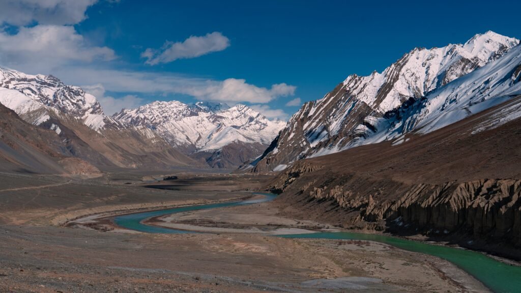
The valleys between these ranges – the Indus, Shyok, Nubra, Suru, Zanskar, and Changthang, define the inhabited and traveller-accessible geography.
Leh District, 45,110 sq km; second largest district in India by area contains the Indus main valley, the Nubra valley (north of Khardung La), the Shyok valley, and the eastern Changthang plateau where Pangong Lake and Tso Moriri sit.
The district borders Xinjiang (China) to the north, Tibet to the east, and Himachal Pradesh to the south.
Kargil District, 14,036 sq km holds the Suru Valley, Dras (claimed as the second coldest inhabited place in the world);
The Zanskar Valley, and the Line of Control with Pakistan. Kargil town saw the 1999 Kargil War; the Dras War Memorial is the most visited memorial site in the territory.
The Changthang Plateau in the east – mostly above 4,500m, is the high-altitude cold desert home of the Changpa nomads;
The Black-necked Crane breeding grounds, and some of the darkest skies in Asia.
The Zanskar Valley, accessible by road only in summer and historically cut off in winter except via the Chadar frozen river route, is the most isolated inhabited valley in India.
Climate: cold desert; most of Ladakh receives less than 100mm of rainfall annually and lies in the rain shadow of both the Himalayas and the Zanskar Range.
Summers (Jun–Sep) are clear, warm (up to 30°C in Leh valley), and short. Winters are extreme (−30°C in Changthang; −15°C in Leh); most passes close November to May, sometimes June.
Ladakh a Glance
| Status | Union Territory (since October 31, 2019); no elected legislature |
| Districts | 2 (Leh and Kargil); 5 additional proposed, pending formal notification |
| Area | ~59,000 sq km (India-administered) |
| Altitude range | ~2,500m (lower Suru Valley) to 7,672m (Saser Kangri massif) |
| Leh altitude | ~3,524m |
| Primary river | Indus |
| Religion | ~46% Muslim (Kargil); ~40% Buddhist (Leh); 97% tribal population |
| Known for | Motorcycle and overland expeditions, Snow Leopard tracking, Buddhist monasteries, high-altitude lakes, Chadar frozen river trek, dark-sky astronomy |
Five Areas Worth Going Deeper Than the Pangong Postcard
These five areas offer the highest GDT MVP experience density in Ladakh, selected beyond the mass-visited Pangong and Leh city circuit.
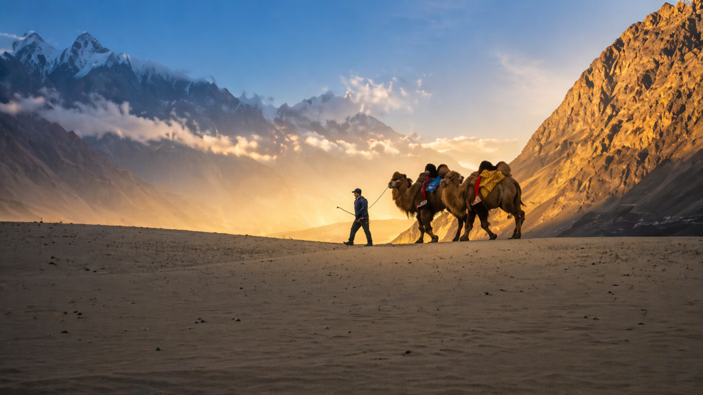
Nubra Valley
Leh district; north of Khardung La, 5,359m; altitude range 2,700–4,500m, drops from the high pass into a warm, wide valley where the Shyok and Nubra rivers meet.
Apricot trees grow at 3,000m, and a population of double-humped Bactrian camels roams the Hunder sand dunes.
The camels are the descendants of animals used by Central Asian merchants on the Silk Road’s Karakoram trade route; they are found almost no where else in India.
Diskit Monastery (17th century; 32m Maitreya Buddha statue facing the Siachen region) anchors the valley’s Buddhist character.
Turtuk, the northernmost village accessible to Indian civilians, culturally Balti and until 1971 in Pakistani territory, is a 3-hour drive from Diskit along the Shyok River.
Experiences: motorcycle expedition, overland self-drive, 4×4 off-roading (Hunder sand dunes, Wari La alternate route), camel safari, cultural living (Balti culture in Turtuk), camping, nature/mountain stays, craft (Nubra apricot oil, weavings).
Tso Moriri and Changthang Plateau
Leh district, eastern Ladakh; Tso Moriri at ~4,522m) is the remotest accessible lake zone in Ladakh and among the finest dark-sky camping destinations in Asia.
The lake – a Ramsar wetland, is the primary Indian breeding ground of the Black-necked Crane, one of the world’s rarest crane species, visible from May to September.
The Changpa nomads herd their pashmina goats across the surrounding plateau, relocating 8–10 times a year between summer and winter pastures at altitudes where few other human communities survive.
Korzok village (4,522m) on the lake’s western shore is the highest permanently inhabited village in Ladakh.
Hanle (4,500m), two hours south, hosts the Indian Astronomical Observatory – one of the world’s highest optical telescopes and the centrepiece of a proposed dark-sky reserve.
Experiences: astro-photography (Hanle Dark Sky Reserve), wildlife (Black-necked Crane, Snow Leopard, Tibetan Wolf, Kiang), camping (no tents inside the Ramsar zone; permitted on periphery), cultural living (Changpa nomads), overland expedition, motorcycle touring.
Zanskar Valley
Kargil district; Padum valley floor at ~3,600m; accessible summer only by road is the most geographically isolated inhabited valley in India;
Ringed by mountain ranges on all sides, road-connected to Kargil only through the Penzi La (4,400m) in summer, and completely cut off by snow from November to April.
For centuries the only winter connection was the Chadar Trek, walking on the frozen Zanskar River when ice forms thick enough to carry people.
The Phugtal (Phuktal) Monaster, a cliff-hanging complex built into a cave face accessible only by a 2-day foot trek from the nearest road is among the most visually extraordinary monastery sites in the world.
Karsha Monastery, visible across the valley from Padum, is the largest in Zanskar.
Experiences: Chadar frozen river trek (January–February; TFS3 winter; verify current status before booking), motorcycle expedition (summer; Padum circuit), cultural living (the most ethnically and linguistically distinct Tibetan-origin community in Ladakh), spiritual immersion (Zanskar’s Drukpa lineage monasteries), camping.
Hemis and Markha Valley
Leh district; Hemis Monastery at ~3,600m; Markha Valley to 4,800m) anchors Ladakh’s most celebrated monastery with its most celebrated wildlife encounter.
Hemis National Park (~4,400 sq km) is home to one of India’s highest-density Snow Leopard populations; winter tracking expeditions (Jan–Mar) with resident wildlife guides are among India’s most sought-after wildlife experiences.
The Markha Valley trek (TFS2–3; 6–8 days; Chilling to Hemis; crossing the Kongmaru La at 5,150m) runs through the heart of the national park, passing through small Buddhist villages, barley fields, and high-altitude pastures with Stok Kangri (6,153m) on the northern horizon.
Hemis Monastery itself – the largest and wealthiest in Ladakh, founded in the 17th century under Drukpa lineage, hosts the Hemis Festival (Jun–Jul; biennial; two-day masked-dance Tsechu ceremony and the unfurling of a giant thangka, the latter occurring only once every twelve years
Alchi and Sham Valley
Leh district; ~3,100m; 70km west of Leh along the Indus) is Ladakh’s most accessible zone for the traveller who wants Buddhist art without altitude stress.
Alchi Monastery – founded in the 10th–11th century by the translator Rinchen Zangpo and decorated with Kashmir-school murals of extraordinary survival:
It iss unique in Ladakh for being on flat ground rather than a hilltop, and for the sophistication of its Buddhist iconographic painting.
Unlike most Ladakhi monasteries, Alchi is no longer an active monastery; it is maintained as a heritage site by Likir Monastery and is genuinely one of the most significant repositories of early Buddhist art in Asia.
The Sham Valley (“Baby Trek”), a 3–5 day walking route from Leh to Lamayuru through lower-altitude Indus valley villages;
is the most accessible Ladakh trek for those arriving from the plains and needing acclimatisation walks at 3,000–4,000m. Lamayuru (3,510m), with its “moonland” geology and 11th-century gompa, is the endpoint.
Experiences: Buddhist art and cultural immersion (Alchi), walking/trekking at moderate altitude (TFS1–2; Sham Valley), cultural living (Indus valley village homestays), cycling (lower Indus gorge), heritage.
Adventure Expeditions That Ladakh Was Built For
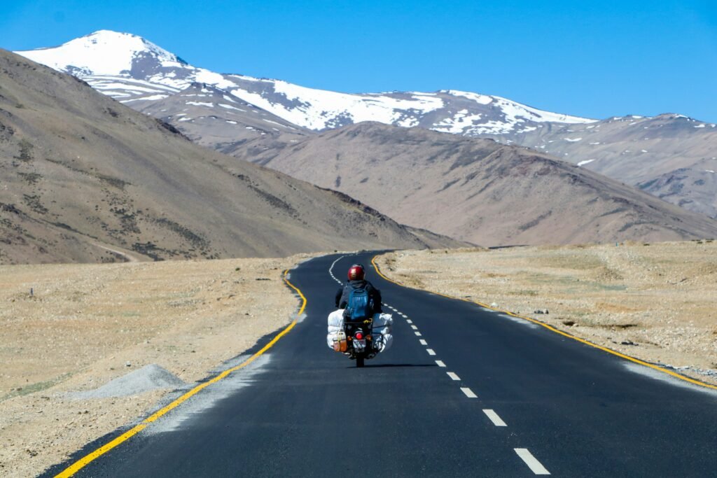
Motorcycle Expeditions and Overland Self-Drive
The Manali–Leh Highway (~479km; via Atal Tunnel/Rohtang, Baralacha La 4,890m, Tanglang La 5,325m) and the Srinagar–Leh Highway (~434km; via Zoji La 3,528m) are two of the most celebrated overland routes in the motorcycling world.
Both open seasonally – Manali-Leh roughly Jun to Oct; Srinagar-Leh roughly May to November.
The Ladakh circuit, entering from one and exiting via the other has become a milestone ride for Indian motorcyclists. Within Ladakh, the Nubra circuit (via Khardung La; return via Wari La), the Changthang loop (Pangong → Chang La → Leh → Tso Moriri → Manali), and the Zanskar approach (Kargil → Penzi La → Padum) are the extensions.
All require Inner Line Permits and adequate vehicle preparation for altitude, river crossings, and remote fuel-stop planning.
4×4 Off-Roading
Ladakh has some of the most demanding 4×4 terrain accessible to civilians in India;
The Nubra Valley routes (particularly the Wari La alternate), the Changthang plateau between Pangong and Tso Moriri, and the approaches to Umling La (5,883m) in southern Changthang.
Umling La, opened by the Border Roads Organisation in 2020, is claimed as the world’s highest motorable road. Access is through a combination of military-designated roads and tourist-accessible approaches; verify current civilian access status before planning.
Trekking
The Markha Valley trek (TFS2–3; 6–8 days; Hemis NP; Kongmaru La 5,150m) is Ladakh’s most celebrated multi-day route.
The Sham Valley (TFS1–2; 3–5 days; Leh to Lamayuru; lower altitude; acclimatisation route), Stok Kangri (TFS4; 6,153m summit; technical peak; crampon and ice axe required), Rumtse–Tso Moriri (TFS3–4; 7 days; 6 passes above 5,000m; Changthang traverse), and the Zanskar river route (TFS3) are the principal options.
All summer treks require adequate acclimatisation in Leh before departure.
[TFS rating is a trek difficulty grading, developed by GDT with the help of combined experience of community of trekker and mountaineers. We published a must read guide for serious trekkers]
Chadar Trek (Frozen River Trek): The Chadar, walking on the frozen surface of the Zanskar River in Jan–Feb when ice reaches the thickness required to carry people, is unlike any other trek in India.
It is not a high-altitude trek (maximum ~3,600m) but an extreme cold-weather expedition: temperatures drop to −30°C, the ice cracks and shifts underfoot, and there are no bail-out options once inside the gorge.
The route is the historic winter lifeline of the Zanskar Valley, used by the community when all road passes are closed.
[NGT orders have periodically restricted or closed the Chadar Trek on environmental grounds; confirm most recent operational status before planing]
Skiing and Winter Sports: Kargil district has ski slopes being developed at Drass and in the Suru Valley; a snow sports centre was proposed.
Leh itself sees some ski touring on surrounding ridges. None reach Gulmarg standards.
Ladakh’s ski infrastructure is embryonic but the terrain and snow quality are exceptional.
Rafting and Kayaking: The Zanskar River confluence with the Indus (Nimu, near Leh) runs Grade IV white-water in summer when snowmelt is high.
The Indus from Phey to Nimu and from Upshi to Saspol offer Grade II–III runs suitable for beginners.
Commercial rafting operations run from July to September.
Ladakh’s Wildlife Story – A Crane That Breeds at 4,500m and a Cat That Almost No One Sees
Snow Leopard – Hemis National Park
Hemis NP (~4,400 sq km), largest NP in India, is the premier Snow Leopard tracking destination in India.
The park holds one of the highest-density populations of the species anywhere in its range.
Winter tracking (Jan–Mar) is managed by specialist wildlife operators who work with local village-based trackers using camera trap data to locate active territories.
The high contrast of snow against rock in winter makes visual sightings more likely than in summer.
Snow Leopard tracking requires a minimum of 5–7 days in the field with experienced guides and tolerance for sub-zero temperatures and long stillness.
Alongside Snow Leopard, Hemis NP holds Tibetan Wolf, Asiatic Ibex, Blue Sheep (Bharal), Ladakh Urial, and Himalayan Brown Bear.
Black-necked Crane – Tso Moriri
Tso Moriri (Ramsar wetland; ~4,522m) is one of very few Indian breeding grounds for the Black-necked Crane, a species classified as Vulnerable on the IUCN Red List.
The cranes arrive in Apr–May and breed through the summer, departing before the lake freezes in winter.
Spotting them on the lake shore in the early morning, against the backdrop of the 6,000m peaks of the Changthang range, is among the most rare bird encounters available in India without crossing an international border.
Changthang Plateau Fauna
The Changthang (Rupshu) plateau hosts the largest congregation of Tibetan Wild Ass (Kiang) in India, herds of hundreds visible from the roads between Tso Moriri and Hanle.
The plateau also holds Tibetan Gazelle, Black-necked Crane, Bar-headed Goose, and winter raptors including Upland Buzzard and Rough-legged Hawk.
Nubra Valley Birding
The Nubra Valley’s apricot orchards and riverine vegetation support a distinct bird community including the White-rumped Vulture, Saker Falcon, and passerines of Central Asian affinity rarely seen in the rest of India.
| Zone | Signature wildlife | Best season |
|---|---|---|
| Hemis National Park | Snow Leopard, Tibetan Wolf, Ibex | Jan–Mar (Snow Leopard tracking); Jun–Sep (Markha trek) |
| Tso Moriri and Changthang | Black-necked Crane, Kiang, Tibetan Gazelle | May–Sep (cranes); Dec–Feb (Snow Leopard descends) |
| Nubra Valley | Saker Falcon, White-rumped Vulture, Bactrian camels | Jun–Sep |
Wellness Ladakh Offers the Body and Mind: Ancient Medicine, Hot Springs, and Silence
Sowa Rigpa – Traditional Tibetan Medicine
Ladakh is the primary centre of Sowa Rigpa (traditional Tibetan medicine) in India outside of Dharamshala.
The ancient healing system that integrates pulse diagnosis, herbal formulations, and astrological-calendrical assessment.
The Central Institute for Buddhist Studies and Sowa Rigpa practitioners in Leh offer consultations;
The Union Territory government has been developing a national Sowa Rigpa research centre in Leh (proposed with 100-bed clinical facility).
Traditional amchi (Tibetan medicine practitioners) in villages across Leh district maintain localised practice.
Hot springs – Chumathang and Panamik
Chumathang (4,100m; ~150km from Leh on the Manali road via Nyoma; sulphur springs at 50–60°C) and Panamik (Nubra Valley; sulphur springs; 3,084m) are the principal natural hot spring sites in Ladakh.
Both are embedded in spectacular high-altitude landscapes and have basic bathing facilities; neither is a developed wellness destination.
The extreme temperature contrast – 60°C spring water in an environment where the air is below freezing, is the experience itself.
Meditation and Contemplative Retreat
The monastery complex at Stok, Thiksey, and Hemis accepts guests for extended stays and meditation in summer months.
The serene, high-altitude, noise-absent environment, combined with the presence of practicing monastic communities.
Creates one of the most distinctive meditation settings in India.
Unlike Rishikesh or Dharamshala, these are not structured retreat programmes; stays are arranged directly with individual monasteries on an informal basis.
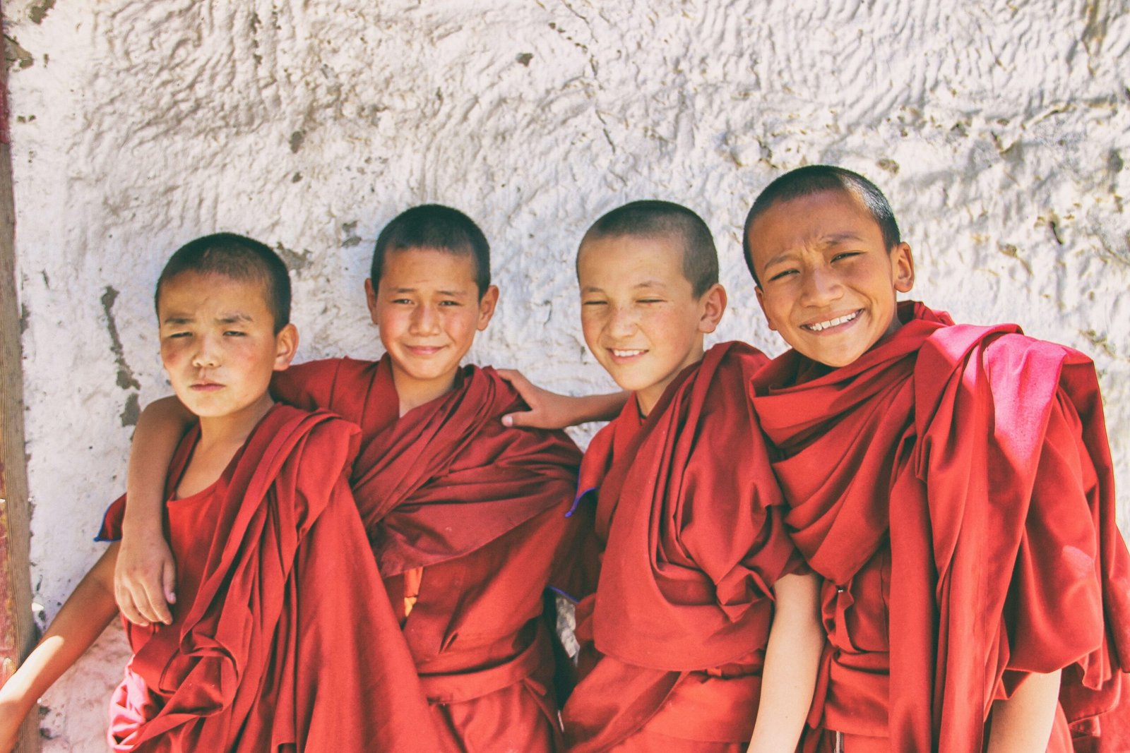
A Twelve Centuries Old Ladakh Culture – Still in Daily Use
The Monastery Circuit
Ladakh’s monasteries are not ancient monuments in a museum sense;
They are active centres of Tibetan Buddhism in the Gelugpa, Drukpa, and Kagyupa traditions, with resident lamas, regular puja (prayer) schedules, and festival cycles that predate the existence of the Indian nation-state.
The principal circuit from Leh-Spituk, Phyang, Likir, Alchi, Lamayuru (westward);
Thiksey, Hemis, Chemrey, Takthok (eastward) – covers over a thousand years of Buddhist institutional history in two days’ drive.
The monasteries vary sharply in character:
Alchi for art, Hemis for wealth and festival, Lamayuru for geology and antiquity, Thiksey for the 12m Maitreya and valley panorama, Diskit for the Maitreya facing the Siachen and the emotional weight of its placement.
Leh Palace and Namgyal Dynasty Heritage
The 9-storey Leh Palace, built in the 17th century by King Singge Namgyal and modelled on the Potala Palace in Lhasa, sits above Leh town on a rock spur and remains one of the most architecturally significant structures in the Indian Himalaya.
The Namgyal Tsemo Monastery above the Palace and the ruined fortress walls give the Leh skyline a silhouette unlike any other hill town in India.
The palace is accessible to visitors; its upper floors have been restored by the Archaeological Survey of India with interpretive content on Ladakhi history.
Kargil and the Shia Muslim Tradition
The cultural geography of Kargil district is entirely distinct from Leh – mosques rather than monasteries;
The call to prayer echoing through the Suru Valley rather than monastery horns; the Balti and Purig communities with their Persian-inflected Shia Islamic heritage.
The Dras War Memorial (Kargil War 1999) is a deeply affecting site; the Batalik sector, Turtuk, and the Mushkoh Valley carry the Kargil conflict’s physical and human geography for those who seek it.
Kargil’s cultural landscape is among the least-documented and least-visited in India relative to its depth.
Hemis Festival
The Hemis Festival (Jun–Jul) – 2-day event at Hemis Monastery; biennial cham, masked dance, with a larger event once every twelve years when the giant Thangka of Guru Rinpoche is unfurled, is the most significant public Buddhist festival in Ladakh.
The masked Cham dances enact the defeat of negative forces and the preservation of the Dharma;
The costumes and masks are among the most elaborate in the Himalayan Buddhist tradition. It takes place inside the monastery courtyard, an enclosed space that amplifies the drums, horns, and cymbals.
Changpa Nomads and Pashmina
The Changpa of the Changthang plateau are one of the world’s highest-altitude pastoral communities, moving their herds of pashmina goats, yaks, and sheep between summer pastures above 5,000m and winter camps at 4,000m.
The cashmere (pashmina) fibre produced by their goats is the raw material of one of India’s most prized luxury textiles.
Visitors on the Changthang route (Tso Moriri, Hanle) encounter their camps unpredictably.
The Changpa do not maintain fixed locations.
Tea shared in a black yak-wool tent at 4,600m is among the most unlikely cultural encounters in India.
Festival with Minimal Tourist Footprint
The Matho Nagrang festival (Feb; Matho Monastery, near Leh) involves a remarkable oracular tradition:
Two monks enter a state of trance, are believed to be possessed by protective deities, and perform feats. Blindfolded navigation of the monastery roof, self-inflicted ritual cuts during the ceremony.
Unlike Hemis, which draws hundreds of tourists, Matho Nagrang is attended almost entirely by the local Ladakhi community.
The ceremony cannot be packaged or pre-arranged; attending requires being in Leh in February when the festival dates are confirmed by the monastery.
Ladakhi Cuisine
Ladakhi food reflects the altitude and cultural layering of the territory.
Thukpa (noodle soup; the daily meal of Buddhist Ladakh, prepared with hand-pulled noodles, vegetables, and meat where available) and momos (steamed dumplings) are the Tibetan foundation shared across all communities.
Tsampa (roasted barley flour mixed with butter tea into a thick dough, eaten by hand; the historic staple of every Himalayan pastoralist) is rarely offered in restaurants but is the functional food of the Changpa.
Butter tea (po cha; tea churned with yak butter and salt) is the correct response to altitude and cold; its salinity and fat content are physiologically appropriate at 4,000m+ in a way that sweet tea is not.
Skyu (thick pasta-like dumplings with vegetables and meat; a heavier, slow-cooked Ladakhi winter dish) is the closest thing to a ceremonial Ladakhi meal, cooked for festivals and occasions that call for gathering.
The occasion and the community gather first; the food serves them.
The Month-by-Month Truth About Timing a Ladakh Trip – When to Go Where
| Zone | Best window | Secondary | Avoid |
|---|---|---|---|
| Leh city and monastery circuit | May–Sep | Oct (clear, cold) | Nov–Apr (very cold; some roads closed) |
| Nubra Valley | Jun–Sep | May; Oct | Nov–May (Khardung La unpredictable) |
| Pangong and Changthang | Jun–Sep | Oct (pre-freeze clarity) | Nov–May (passes closed; extreme cold) |
| Tso Moriri (cranes) | May–Sep | — | Oct–Apr (cranes departed; lake freezes) |
| Zanskar (summer road) | Jun–Sep | Oct (brief) | Nov–May (road closed) |
| Chadar trek (Zanskar frozen river) | Jan–Feb | — | Any other month (river not frozen) |
| Snow Leopard tracking (Hemis NP) | Jan–Mar | — | Apr–Dec (Snow Leopard in high terrain; sightings rare) |
| Dark-sky / astro-photography (Hanle) | Jun–Sep; Nov–Feb | Year-round if weather permits | Mar–May (spring winds) |
Acclimatisation is mandatory before any Ladakh activity
Leh sits at 3,524m, arriving directly by air from sea-level cities and beginning activity the same day causes Acute Mountain Sickness in the majority of visitors.
Standard protocol: 2 full rest days in Leh before any excursion above 4,000m; ascend gradually; avoid flights from Delhi to Leh and same-day departure to Nubra or Pangong.
Inner Line Permits: What You Need, Where to Apply
All visitors to restricted areas in Ladakh require permits.
This is non-negotiable and enforced at multiple checkpoints.
Indian nationals need Inner Line Permits (ILP); foreign nationals need both ILP and in some zones Protected Area Permits (PAP).
Restricted zones requiring ILP for ALL Visitors:
Nubra Valley, Pangong Lake, Tso Moriri and Rupshu (Changthang), Hanle, Turtuk, and several other border-area destinations.
Apply online at Leh District Permit Tracking System (recommended for speed) or in person at the Deputy Commissioner office, Leh. Permits are free and processed same-day online.
Foreign nationals – additional PAP required for:
Specific zones near the Pakistan and China borders; requirements change with security situation; verify at the time of travel.
Foreigners must travel to certain restricted zones in groups of 4+ with a registered Indian travel agent.
Registered Tourist Requirement:
All visitors must register at tourism checkpoints; keep multiple ID copies and permit printouts at hand.
Military presence is visible and active at all checkpoints; cooperate fully and carry documents at all times.
[It is recommended to verify current permit regulations, these change frequently with the security situation. Get an up-to-date verification from the Leh DC office or official tourism portal]
Getting to Ladakh
| Mode | From | Route | Approx time |
|---|---|---|---|
| Air – Leh (IXL) | Delhi (DEL) | Direct; multiple daily flights; only reliable year-round access | 1 hr 15 min |
| Air – Leh (IXL) | Mumbai, Bengaluru, Srinagar | Direct or 1-stop; fewer frequencies | 2–3 hrs |
| Road – Srinagar-Leh Highway (NH 1) | Srinagar | Via Zoji La (3,528m); ~434km; scenic; army convoys | 2 days; open May–Nov |
| Road – Manali-Leh Highway | Manali | Via Atal Tunnel/Rohtang, Baralacha La, Tanglang La; ~479km | 2 days; open Jun–Oct |
No railway connection exists in Ladakh.
Air is the only practical year-round option for most visitors.
Both road routes require 2 days with an overnight halt (Kargil on the Srinagar route; Jispa or Sarchu on the Manali route); both close seasonally.
Road travel from Manali via the Atal Tunnel gives access to Lahaul regardless of season; Rohtang and the high passes above remain seasonal.
Bringing or renting a motorcycle for the road approach is the most complete overland experience, but requires prior high-altitude driving experience and a mechanically sound machine.
Getting Around
Leh is the hub for all movement in Ladakh.
Shared taxis from Leh taxi stand connect to all major destinations; private hire is the standard for destinations requiring full-day driving (Pangong, Nubra, Tso Moriri).
Self-drive rental of Royal Enfields and SUVs is available in Leh with appropriate documentation;
Verify permit carriage requirements for self-driven vehicles in restricted zones.
The Leh market area, Shanti Stupa, and monastery circuit west of Leh are accessible by local shared taxis.
Above Leh and into all restricted zones, arrange transport the previous evening, early morning starts are essential for most destinations given driving distances and checkpoint timings.
What Experienced Ladakh Travellers Ask Before They Arrive – FAQ
How long does it take to acclimatise in Leh before I can trek or go to Pangong?
Most visitors need 2 full days of rest in Leh (at 3,524m) before attempting excursions to 4,000m+ destinations like Pangong or Nubra.
Day 1 and 2: rest, short flat walks, hydration, no alcohol, no exertion.
Day 3 onwards: short drives or gentle walks at moderate altitude.
Rushing this is the single most common cause of trip disruption in Ladakh.
AMS symptoms (headache, nausea, breathlessness at rest) require descent, not pushing through.
Do Indian citizens need permits to visit Nubra Valley and Pangong Lake?
Yes. Inner Line Permits (ILP) are required for all visitors – Indian and foreign, to Nubra, Pangong, Tso Moriri, Hanle, and several other zones.
Apply online at Leh District Permit Tracking System (recommended; same-day processing) or at the DC office in Leh. Carry multiple printed copies and your original ID; checkpoints are frequent and enforcement is strict.
When is the best time to see the Snow Leopard in Ladakh?
January to March at Hemis National Park.
Snow Leopards follow their prey (Blue Sheep and Ibex) to lower altitudes in winter when snow forces the herds down, making them more visible against the white background than in summer.
Winter tracking expeditions (minimum 5–7 days) with specialist operators using camera trap intelligence offer the most reliable sighting chances.
Temperatures are −15 to −30°C; proper cold-weather gear is essential.
Is Khardung La still the world’s highest motorable pass?
No.
The Umling La pass (5,883m) in the Changthang region, opened by the Border Roads Organisation in 2020, surpasses Khardung La (approximately 5,359m) in verified altitude.
Umling La is on a military-access road with restricted civilian access; verify current access status. Khardung La remains a significant high pass and a meaningful overland achievement.
The claim to “world’s highest” is no longer accurate.
What is the Chadar Trek and is it currently open?
The Chadar is a winter trek on the frozen surface of the Zanskar River.
The gorge that cuts through the mountains between Zanskar Valley and the Indus. It runs in Jan–Feb when ice builds thick enough to carry people.
The route was historically the winter lifeline of Zanskar.
Environmental concerns have led to periodic restrictions by the National Green Tribunal; verify current operational status with Leh-based operators before planning, as regulations change season to season.
What is the cultural difference between Leh and Kargil?
Leh district is predominantly Tibetan Buddhist, monasteries, prayer flags, mani walls, and butter lamp festivals define its cultural landscape.
Kargil district is predominantly Shia Muslim – mosques, Muharram observances, and the Balti and Purig cultural traditions shape its identity.
The two districts are culturally more distinct from each other than either is from India’s neighbouring regions.
Buddhist Leh resembles Spiti; Muslim Kargil has closer parallels with Gilgit-Baltistan.
Both deserve separate visits; most Ladakh itineraries focus almost entirely on Leh district.